
One of the defining aspects of this campaign is my choice to run this on the real, actual Isle of Wight. I had thought about filing off the serial numbers, but the more time I spent poring over Google Maps, the more tempted I was to use the real place.

Approaching the Needles Tourist Attraction
The sheer amount of information here is truly overwhelming, but also like catnip to my brain. For one thing, players can get a good map of the whole place that really kicks player planning up a notch.
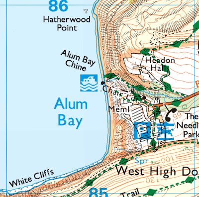
Ordnance Survey - Needles Attraction Area
When the players get to a location, I can actually pull out Google street view and show what it looks like.

"It looks like this, only the bus is burned"
Then when you get to a location, the GM can actually pull out google street view and make it really clear what the players are dealing with, and what it feels like to be there.
Preparing a Real Place
I forget how he put it, but Ken Hite once said that a sandbox is a load of sand your players can do anything with, but it's also great to have a bunch of plastic dinosaurs buried for them to find. This feels like phase 2 of my prep that I'm only now starting to enter, before this I had to figure out how to handle players going anywhere.
Dungeons are deliberately constraining, but I've got almost the opposite - the players have a motorboat, which means they can go to a huge number of places on the island. A circuit of the island is less than 100km, so they can pull into any cove, isolated bed and breakfast, seaside self-catered holiday cottages, and any of a number of actual towns, villages, manors, pubs, and other facilities.
The only way to handle all this is to have a set of tables, enough to be able to roll with any location the players might visit.
The Big Weather Table
Instead of having a weather table to roll on, I decided to pre-roll the weather. The players are starting on a cargo ship, making day and night forays through swift tides, landing on rocky coasts or via estuaries that turn into mud beds at low tide. For this reason, I built out a fairly comprehensive weather table:

I'm especially fond of the little tides notation:
↑12:00 ←14:52 ↓17:45 →20:37 ↑23:30
This is ↑ high tide at noon, peak ← westward flow in the afternoon, ↓ low tide at supper, eastward flow in late evening and then the second ↑ high tide just before midnight.
There's a similar one for the moon (which is important when the players are sneaking around at night without lights):
↑07:00 🌓13:15 ↓19:30
That's a 🌓 waxing moon that ↑ rises at 7 AM, highest at 1:15 PM, then ↓ setting after supper. (What's important about this is that the moon is up in the day, and will provide no light at night even if the sky is clear.)
Making a big weather table like this does take time, but I'm now firmly in favor, for two reasons:
- Handling time is much faster than randomly rolling the weather. I just switch to the Weather tab and there it is, today's weather.
- I never forget to roll. There's always some weather (even if it's nice).
Because of these two effects, even though the weather and tides have not yet been a meaningful bother, they're always there adding a little bit of texture.
Other Tables
I won't share the actual content of the other tables so as not to reveal the man behind the curtain to my players, but here's what I've made so far:
- Day and night encounter tables for town streets, parks, rural areas, and coastlines.
- Random situation for street intersections, accumulations of cars (lots, crashes, jams)
- Vehicle types and condition (e.g. burned, out of fuel).
- Car crash damage table
- Random infected behavior tables.
Like Year Zero "monster combat action" tables, so far these have been really good for creating slightly chaotic encounters without me feeling on the hook for setting the danger level. - Site condition table - what's going on in this building?
This one has a few dimensions, based on the location on the island (mostly, how close was it to the initial spread of the infection), and then how lucky was it? - Loot tables for cars, service vehicles, farm buildings, clinics, restaurants, households, campsites, bakeries, shooting ranges, and aircraft.
- Survivor tables: what they're doing now, their reaction, how they make decisions, where they're based, the state of the group back at the base, their larger-scale goal and anti-goal (e.g. communicate with other groups, hiding will just get us all starved), their theory about the infection, and what they know about the infected.
Most of these tables were made by hand, but I do have to say that for random loot tables, ChatGPT is incredibly useful. Of course, all the obvious caveats about ChatGPT apply, but for scutwork tasks like, 'list the shit that's in a rural village medical clinic in the UK in 1989', it's very very fast.
I've now got a prompt that will let me just specify a context, and it will produce output that I can just paste into my self-rolling tables sheet. It's fast enough that I can make and add a new table during play, in about the same amount of time it would have taken me to roll random treasure.
Again, this works specifically because of the kind of game this is. I'd never use this for the cool treasure in the wizard's vault, but for generating the picked-over contents of a blood-spattered .. uh.. aerospace research factory, it's a godsend.
Self-Rolling Tables!
I may write more detail about this in another post, but one of the best things I did with my tables is make them all self-rolling. They're in google sheets, and so every table has one or more die rolls to generate a series of results, and the table highlights itself to show those results.
This is a self-rolling car damage table:

Like the weather table, this means the handling time is incredibly short. I just have to flip to the Loot tab and this is there for me to read off and weave into the description:

These loot tables are rolling on other, much larger tables and pulling out an appropriate number random finds. Pre-rolled loot is especially helpful for me because the players are moving through places that in some cases aren't picked over. When they say, "What's in the car's trunk?" it's amazing to be able to just smoothly transition to narrating them popping open trunks and peering in windows and telling them what's there .. instead of having to stop roll a bunch of dice.
* * *
With all this, I'm able to handle most specific locations, but there are a few situations that still give me pause, namely broad vistas. If the players can see a whole residential neighbourhood (because they're up on a hill), I still don't have a tool to help me generate the overall impression. So far, this has never come up because the Isle of Wight has incredibly steep coastlines in many places, so from the water you can really only see stuff just beyond the beach. But as soon as the players reach somewhere like Cowes, or drive along the Medina river inland.. hoo boy.
The self-rolling tables idea is pretty good, I'm usually running sessions at a table, but I might get it to work with an iPad or something? One of my players use a reMarkable tablet for Twilight 2000 recordkeeping, I wonder if that could be made to work? I really like the e-ink screen and pen, better for at-the-table sessions than a glowing iPad and fingers.
ReplyDeleteI realized IoW is very close to the mainland Britain, are you planning to discourage the players from going over there?
ReplyDeleteI think ultimately, no, but in the short term there are some not-so-subtle cues, like 'WELCOME TO THE ISLE OF WIGHT CAMPAIGN' and everyone's playing along. In the last session we did discuss it a little bit, because the players have taken control of the (contaminated) Fort Albert on the coast, which is a stone's throw from the narrowest span of the solent. All the pictures we find of Fort Albert on google have the mainland in the background. :)
DeleteIf the campaign goes on long enough I'm sure mainland forays will become a thing, but in 'West Marches danger level is higher the further from home', it will be a step function worse there.